The primary purpose of this website is to provide accurate and authentic information about Onitsha.
Onitsha is a city located in the southeastern part of Nigeria, specifically in Anambra State. Here’s an overview of its geography:
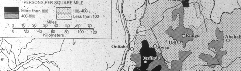
Location
Onitsha is situated on the eastern bank of the Niger River, approximately 40 kilometers (25 miles) north of the Niger Delta.
Climate
Onitsha has a tropical savanna climate with:
– High temperatures and humidity throughout the year
– Average temperature: 23°C – 30°C (73°F – 86°F)
– Two main seasons:
– Warm and humid wet season (March – October)
– Hot and dry season (November – February).
Topography
Onitsha is situated in the Niger Valley, with a relatively flat terrain. The city’s elevation is around 30 meters (100 feet) above sea level.
Waterways
The Niger River plays a significant role in Onitsha’s geography, providing a major transportation route and supporting the city’s economic activities, such as trade and fishing.
Vegetation
The surrounding area is characterized by tropical savanna vegetation, with grasslands, shrubs, and trees dominating the landscape.
Urban Layout
Onitsha is a densely populated city, with a mix of residential, commercial, and industrial areas. The city’s layout is characterized by narrow streets, markets, and a bustling commercial center.
Challenges
Onitsha faces geographical challenges, including flooding, erosion, and environmental degradation, which affect the city’s infrastructure, economy, and residents’ quality of life
Vital Statistics
Demographics
1. Population: 1.695 million (metropolitan area), 7,985,643 (urban area)
2. Land Area: 830 km² (metropolis), 614.12 km² (land), 0.067 km² (water)
3. Density: 4,100 people/km² (urban)
Economy
1. GDP: $18.5 billion
2. Per Capita GDP: $11,400
Source: Wikipedia